

Your basket is empty.
-
- Books
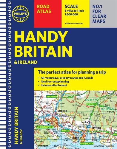
Philip's Handy Road Atlas Britain: (Spiral A5) - Philip's Road Atlases (Spiral bound)
Philip's Maps (author)Published: 14/10/2021
"The perfect atlas for planning a trip anywhere in the UK and Ireland"
The essential handy road atlas for planning a trip in Britain and Ireland. Keep it in the glove box or your travel bag for quick and easy reference.
This gem of a glove-box sized atlas has all the core information you need for driving around the British Isles. It includes all the motorways, primary roads and A Roads and they are clearly shown - ideal for route planning. There is a separate 4-page road map of Ireland for easy use. Alongside that, this handy atlas includes a key map, a distance table and useful counties map.
All the towns and villages listed within are indexed and all the information comes in a handy glove-box size format with practical, lie-flat spiral binding. With the scale at a user-friendly 8 miles to 1 inch / 1:500,000 (Ireland 19 miles to 1 inch /1:1,200,000) and fully up-to-date using Philip's clear mapping, you will never be at a loss to establish the best route.
Keep in the car or sling in your bag before travelling, the Philip's Handy Road Atlas of Britain is also great value at only £5.99.
Publisher: Octopus Publishing Group
ISBN: 9781849075770
Number of pages: 80
Weight: 140 g
Dimensions: 208 x 158 x 6 mm
You may also be interested in...


Please sign in to write a review
Sign In / Register
Sign In
Download the Waterstones App
Would you like to proceed to the App store to download the Waterstones App?